 |
| In front of Table Mountain in Cape Town |
We arrived in Hermanus, at a different time of year I would be really excited, you can see whales on the ‘humpback highway’ but not now...
A ‘proper’ hotel, greeted with a welcome glass of wine.
We had a gentle saunter along a section of the whale path before posting the last blog and going out to eat. We are having to make our own decisions, very hard!
 |
| Outside our hotel in Hermanus |
 |
| African penguins at Stony Point, Bettys Bay |
Our destination? Cape Town, but not direct, first stop Betty’s beach. A small carpark and a small penguin colony, but on our arrival at 09.00 we were the only ones there (location:34°22'16.4"S 18°53'32.9"E). Penguins are lovely, I had to ‘explain’ to the twitchers, we weren’t converted, penguins are honorary mammals.... We herd the braying that gave the South African penguin its original name of jackass penguin, and took ridiculous numbers of photos.
We were very pleased with this unscheduled stop, though suspect it was to delay arrival at our next stop as it would have been far too early to go straight to a wine
 |
| But be careful when you return to your car! |
This was followed by a second wine tasting, this time with a cheese pairing. We preferred these, cheaper, wines, but still didn’t buy anything, though some did! The cellar tour was interesting though.
A very centrally located hotel made finding somewhere for dinner relatively easy, though it’s always tricky when there are 7 people...
 |
| Twitchers at work! (Alis photo) |
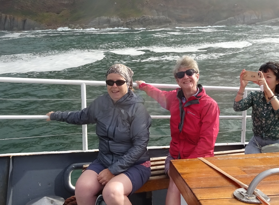 |
| Alison & Jackie enjoying the swell on the seal boat ride |
Exodus trip: day 18
We thought our early starts were over, but no. Breakfast at 06.30 for our last drive, down to the Cape of Good Hope. Our first stop was Hout Bay for a 45 minute boat trip out to seal island (location:34°02'54.1"S 18°20'50.1"E ). It was surprisingly rough and wet, but we loved it. Coffee (the trip has become less frenetic) and then to the light house at Cape Point before walking to the most South westerly (but not most southerly) point of the continent. So not where two oceans meet, but it is where the Cape of Good Hope signs are (location: 34°21'25.4"S 18°28'25.6"E).
 |
| It was very misty and a huge swell that tossed the boat around, but the seals seemed to love it |
 |
| Rainbow in the mist over the bow |
Simonstown for lunch before Boulders beach for penguins (location: 34°11'41.6"S 18°26'49.1"E). There were more penguins, but also more people. We didn’t enjoy it so much, though the penguins are still very cute and we could see some fluffy chicks. Which to do with mum?
An hour or so to chill back at the hotel before the bus arrived to drive us to the V&A Waterfront, the ‘buzzing ‘ bit of Cape Town. A pint followed by a meal in Ocean Basket all went down very well. Though we didn’t manage to make
 |
| And plenty of surf crashing around us as we were tossed about |
Exodus trip: day 18
And why did we want an early retreat? Chantel was collecting Brian and I and our packed breakfasts at 06.00 as we were going to hike up Table Mountain (location: 33°57'19.4"S 18°24'57.1"E). With a warm day (32 degrees) forecast an early start was required! I don’t think we broke any records, but 2 hours up many steps is pretty good going, 2 1/2 is pretty standard! Very pleased we did it, great views, beat the crowds, feel smug, and with the cable car don’t even have to walk down!
 |
| But this sea lion floating about in the harbour calmed us down |
“Where is the photo of the really flat ‘table’ taken from?” B asked. “On the beach just by where I live” said Chantel. So rather than just drop us off at the hotel, she dropped us at the beach, popped home for a shower and to collect her laptop before collecting us and returning us to the hotel. Brian is a very happy boy! Location: 33°51'43.5"S 18°29'19.6"E
A quick doze (it hadn’t been a good nights sleep) and write of the blog. We might make it out again before we all meet up for our final dinner, but who knows. And tomorrow? Stevie is taking us and our bags to our next hotel before taking us to the airport to collect the next hire car and mum! Phase 4 is about to start...
 |
| At the Cape of Good Hope, the most south-westerly point |
 |
| Walking the path to the Cape |
 |
| On the high ground about to descend to the Cape. LtoR: Jackie, Chantel, Andy, Ali, Peter and Alison |
 |
| Of course you can go up to the lighthouse on a funicular railway (we walked!) called the Flying Dutchman. It is called that after the ship that sank in a storm in the 18th (I think) century after the captain insisted they try to round the Cape rather than waiting out the storm in False Bay. It didn't make it and sank with the loss of all hands and it is said that a ghost of the ship regularly sails the waters here |
 |
| Here is a view of Table Mountain with its table cloth on. This happens often in summer afternoons when the cool sea breeze blows in from the Atlantic cloaking the mountain in a mist that looks like a table cloth |
 |
| Here's Jackie looking for whales in False Bay. I'm certain I saw one blowing a jet of water, even though its out of season. Peter and Jackie saw the aftermath and a large body breaking the surface. We didn't see it again though |
 |
| Its early morning not long after sunrise on the lower slopes of Table Mountain with Cape Town in the distance and this is Chantel and Jackie preparing to start our Plattenkip Gorge hike up Table Mountain |
 |
| Here we are at the start. About 700m of ascent |
 |
| Halfway up and Chantel takes a selfie of us |
 |
| We're getting there, the top of the gorge is in sight |
 |
| A look back through the gorge to Cape Town far below |
 |
| And finally we make it to the top with views behind towards the Cape of Good Hope |
 |
| Expansive views of Table Bay, Cape Town and suburbs |
 |
| We saved the knees and took the cable car back down. This is on the way down and in from the the pointy peak of Lions Head, the lower hill to the right is Signal Hill and beyond it in the Atlantic is Robben Island, where Nelson Mandela was imprisoned. The rest of our group had booked a tour out there today but, unbelievably it was cancelled due, they said, to bad weather. We can see it, there's very little wind and the sea looks calm from here. What exactly is 'bad weather' about that? |
 |
| And so, after getting down, Chantel dropped us off at the beach at Milnerton to take the most iconic photo of Table Mountain in perfect conditions. We are very happy people! By the way, our Plattenkip Gorge trek is just visible. Look at Table Mountain and about a third of the way along from the right is a cleft that slopes downwards to the left, thats our route. The higher looking point on the left is Devils Peak,is a separate mountain in front of Table Mountain and is actually lower in height, but only looks higher due to the angle we're at. Lions Peak is the next hill on the right and Signal Hill is on the extreme right. Surfers were playing in the waves, but the waves here are not very exciting, they are probably just learning |
No comments:
Post a Comment