 |
| Its Christmas in Big Ted! |
I spent most of the ‘pretty’ part of the journey trying to persuade Doris to go the ‘pretty’ route and not go the long way via the motorway. She really is getting a bit touchy. You select her 2nd choice of route, and all seems fine, only to turn her off overnight and back on, she knows where she’s going, but has defaulted to her preferred route! Very irritating. She also seems to be possessed. There are two of her in there, just as
 |
| Finally reached an open campsite on the Mosel River! |
 |
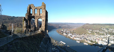
| Views down the Mosel River the next day - all is forgiven! |
 |
| The walk up to the castle ruins was very pretty |
 |
| And as we got higher the views got better and better |
 |
| At the Kriegerdenkmal, the castle ruins are higher up! |
OK, we’ll have some lunch and hunt a bit more, 10 minutes to the next one (it’s obviously very popular here in the summer) but we are heading the wrong way along the river, but we won’t worry about that. Lovely spot, right by the river, no closed signs, but the water has been turned off and the electric points removed. He’s really had enough so “we are stopping anyway”. With that he pulls onto the grass and grinds to a halt! Oops, back and forth, churn it up a bit, no, we are going
 |
| But first, Jackie enjoys the views |
We’ve practiced once, on the drive where you don’t mind kneeling down, but that wasn’t an option! Struggled with the first, then read the instructions and the second one went on much better. Start again with the first. Right, can’t drive hands completely smegged up, as were shoes. Squeezed the keys out of my pocket to the locker where we have the little shower head to make an outside shower. Handy that. Clean hands, shoes off, fingers
 |
| At the ruined castle and what a view! |
Doris takes us to the campsite which we know is shut, but the signs point us to the Aire which seems to be through a lorry yard, but we follow them, only to find a man with a tractor and trailer trying to fix the entrance barrier. He makes a call and sends us to the exit barrier which goes up and we are in! We have a conversation with our no German and her no English, she has no idea why I’m looking so relieved and hugging her, but hey, I’m probably harmless. I suspect she got some idea of the day we’d had when she brought us a scrubbing brush to aid the cleaning of shoes and snow chains of ridiculous quantities of mud! Campsite location: 49°57'29.8"N 7°06'09.8"E
We did have a cup up tea before we started on the wine, but then we drank a lot of wine!
I know, first world problems, nobody died, there was no damage (except for a bit of grass), it was just all a little stressful!
 |
| The gate at the bridge in Trarbach leading to Traban |
We decided to stay two nights, well we were already a day ahead, and there was no way we were going through all that again looking for a second spot along the river, so when we left it would be straight to Trier!
Wednesday was lovely, cold, 2degrees the maximum forecast, but clear and sunny. We walked along the river to Traben-Trarbach, actually two towns, one either side of the river. Tourist information shut (Wednesday) and Christmas market, in the wine cellars of half a dozen vineyards only on on the weekend. Bad vibes again! We do find a street map and make our way up to the ruined castle, for the best view. Only to find we can go up, quite a lot further up. Fab views. Couldn’t see the castle from the campsite in daylight, but once it was lit up in the dark it was obvious!
 |
| Christmas market in Trier and the Dom (Cathedral) St Peters |
Today Trier, slow route along the river? Fast along the motorway? Foggy, cold and very frosty, so what’s the point of a scenic drive? Except that due to a road closure we ended way up high, in the fog, steep roads, no visibility, fortunately no black ice either, not enjoying it very much! Not a problem however, got to Trier, half an hour walk along the river, interesting old town, where old is Roman. We didn’t get very involved in that, but it was interesting, then lovely medieval buildings and Christmas market. Sausage in a bun, waffle with Nutella, still foggy, still only 2degrees, back for a blog then! Parking location: 49°44'27.6"N 6°37'29.4"E
 |
| Impressive interior to the Dom |
 |
| 5m high statue of Karl Marx in Trier. Why? Because he was born in Trier |
 |
| Here's what the information board said about him |


No comments:
Post a Comment